Hey all:
Not a lot to report. We’ve made it into Canada and are waiting out the rain in an Ontario Hotel. We’ve been leap-frogging with our new friends from Wisconsin, Jenny & Wally, who are also here at the hotel. The Brits were a day behind us and entered Canada at a different point - and it looks as if they may pass us on our down day.
The riding through eastern Michigan continued to be through fairly flat farmland, making for easy riding. Our average has increased to approx. 80 miles a day (although the winds still haven't heard that they are supposed to blow from west to east).
This sign could have been placed by the Governor of Wisconsin in his effort to further break the back of labor in his state (although I think, given the economy, that he could offer less than $7500 per worker killed. I still think he'll get a lot of applications for "union" hunting licenses).
A Road Scholar (remember those?) award goes to eastern Michigan for having some of the worst roads for cycling that we have seen so far this trip. Half my fillings are gone and every bolt has come loose on our trikes (ok, a slight exaggeration – but the roads were pretty bad). Another Road Scholar award goes to those folks who design and install bike paths. I very much appreciate the money and time that goes into creating paths for folks on bicycles to get to work, exercise, or cross the country free from the dangers of riding with automobiles and trucks.
The Pere Marquette Trail is a great example of what a bike trail should be: wide, smooth, easy to follow, with well-placed bathrooms along the way. We were able to follow this for almost 60 wonderful miles.
For the other trails builders, there ought to be a few basic rules that they need to follow in constructing these trails:
1. You need to be able to see the signs indicating access points to the path from a bicycle traveling at 10 – 12 miles an hour from a distance of at least 50’. You also may want to inform more than 3 townspeople that there is a trail that runs through their town.
2. There should not be a two to three inch high jarring lip at the entrance and exit points, or where the path intersects with cross streets.
3. All places where one has a choice of multiple paths should be marked with signs indicating where each path goes.
The paths around Bay City and Marine City, Michigan fell somewhat short of these ideals and caused us to get lost for the first time on the trip.
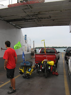
The ferry ride from Michigan to Ontario was very short and cost $1. There were a number of Canadian foot passengers who had made the trip to the states for the sole purpose of purchasing copious quantities of beer. It seems that you can buy Canadian and American beer in the United States, and pay duty on it, for less than it costs to buy the same beer in Canada. They may do universal health care better than us, but we do beer better!!
We’ll next spend three or four days making it across southern Ontario (mostly along the north shore of Lake Erie) before we pass back into the U.S. around Niagra Falls. At our current pace, we may actually make it to Lubec, Maine a week earlier than anticipated. It would be nice to have a couple of days to re-acclimate to life off the bike before heading back to work in CT on the 25th of August.
Hope you are all well.
Take care,
Rob & Jake


I'm curious about who took the candids of you two at the bottom of this blog entry? It's reassuring to see that this trip hasn't changed either of you a bit! Love, Mom/Susan
ReplyDeletecanada...
ReplyDeletewait. i just noticed that jake is wearing an orange shirt. thank you. my life is complete.
ReplyDeleteWas Jake taking a helmet brake in the picture by the stone arch?
ReplyDelete